
YellowScan CloudStation Ultimate
CloudStation is a highly user-friendly software application that allows you to produce point clouds, elevation models, contour lines, orthophotos, and more from YellowScan's LiDAR systems and camera modules.
Read more
Similar products
Description of YellowScan CloudStation Ultimate
CloudStation is YellowScan's proprietary software for processing LiDAR and image data from YellowScan sensors. Here you can produce point clouds, elevation models, contour lines, and orthophotos in an easy-to-navigate workflow.
The software has a modern and user-friendly interface that takes you step by step through the different parts of the process.
CloudStation Ultimate
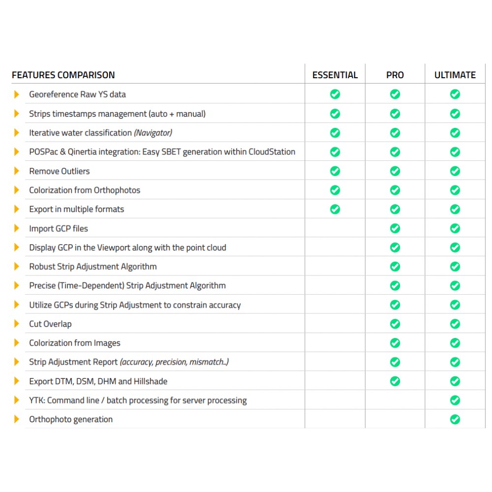
This is the full-scale version of CloudStation, which gives you access to all the features of the software. Just like in CloudStation Essential, you can run an integrated post-processing (PPK) on the trajectory, generate point clouds, and color them with orthophotos.
You also get access to the strip adjustment and terrain classification modules found in CloudStation Pro.
In addition, you can generate orthophotos, export full waveform point clouds from Navigator, and run batch processing with YellowScan Command Line.
Integrated post-processing of trajectory (PPK)
Regardless of which scanner you choose, PPK is used to produce an accurate trajectory (SBET) after the flight. Depending on which scanner you have, you will use either Applanix POSPac or SBG Qinertia. These software programs can be run separately, with their own GUI, or through an integrated workflow within CloudStation. This is very user-friendly and is usually faster than running directly in POSPac or Qinertia.
Generate point clouds
Once you have created an SBET file, you can generate the point cloud from your raw data. Here you have control over which part of the flight you want to generate data from, through an automatic or manual definition of each strip. You can choose which FOV from the scanner you want to retrieve data from, etc.
Measure and visualize the point cloud
YellowScan has developed its own 3D engine, and visualizing and inspecting point clouds in CloudStation is very smooth and responsive, even for large datasets.
You can choose between different color palettes such as height, intensity, returns, swaths, flight, etc.
You also have tools for measuring distances, making cross-sections, etc.
CloudStation Pro/Ultimate modules
Strip Adjustment module
To reduce deviations between the different strips, you can run strip adjustment on the data. Here you can also retrieve GCPs and use them as control points, checkpoints, or points of interest (POI).
You can choose between robust or precise strip adjustment depending on your needs and the type of flight/data collection you have.
Terrain Classification module
In this module, you classify terrain from other points. You can make various settings to optimize for the type of data or terrain in each individual project. YellowScan has developed its own algorithms for classifying terrain using the various properties you get from LiDAR data, and it can often do a better job than if you run terrain classification in software built for photogrammetry.
Colorization module
If you want to colorize your project with realistic RGB colors, you can do so in the Colorization module. If you have a scanner with a built-in or external camera, you can use these images for colorization. If you don't have a scanner with a camera, you can also colorize using an orthophoto created in other software.
Cut Overlap module
You often fly with 20-30% overlap on LiDAR data in order to run strip adjustment and ensure that you do not lose data in any area. However, if you do not want varying point density in your dataset, you can run Cut Overlap to remove overlapping data between the strips.
Smoothing module
Depending on the scanner, you may get a slightly thicker and "fluffier" point cloud when the scanner does not have such high precision. To get a thinner and sharper point cloud, you can run the smoothing module. Here, advanced algorithms are run to analyze the data and move the points towards the center line. The result is a much sharper and well-defined point cloud.
Generate orthophotos
In CloudStation Ultimate, you can generate orthophotos from both built-in cameras and external camera modules. Orthophotos are also generated using LiDAR data to obtain even more accurate elevation values in the orthophotos. This is done as part of the export flow in CloudStation.
Batch processing
For advanced users who work with large amounts of data or repetitive data collection, it can be inefficient to generate data manually. With CloudStation Ultimate, you can batch process data without opening the software and manually going through the various steps.
Export full waveform data from Navigator
If you want to analyze the full waveform data that you can collect with Navigator, you can use CloudStation Ultimate to export it and then analyze it in other software. The data is exported as full waveform LAS.
Exporting data products
Once you have finished generating and processing the data, it can be exported. In CloudStation Pro, you can export the following products:
- Point clouds - LAS, LAZ, TXT
- DTM, DSM, DHM, and Hillshade
- Contour lines
- EO parameters from RGB camera